Annapurna Circuit Trek is one of the world’s famous high altitude trek offering the best views of the beautiful mountain peaks of the Himalayas. The main highlight of this trek is to pass through the high altitude pass of Thorong-la at an altitude of 5,416m (17,769ft). Other highlights include high altitude villages and towns of Manang and Mustang, Tibetan culture and traditions, beautiful and jaw-dropping Himalayan landscapes, and memorable high altitude trek through the Annapurna mountain range.
Annapurna mountain range located in north-central Nepal and includes the tenth highest mountain peak of the world – Mt. Annapurna(8,091m – 26,545ft), thirteen peaks over 7,000m and sixteen peaks over 6,000m. The whole Annapurna mountain range is over 55 km long having Marshyangdi river on one side and Kaligandaki river on the other side.
The Annapurna Circuit Trek usually starts from Besisahar of Lamjung district of Nepal and typically ends at Pokhara of Kaski district of Nepal and is about 21 days trek. Due to the development of roads to connect local villages, most trekkers choose to use vehicles up to Chame or even up to Manang before starting the trek and most end their trek at Jomsom by flights or take a bus to Pokhara significantly dropping trek days to 7-10 days. The trek has many side treks including trek to Tilicho Lake – highest altitude lake in Nepal (and some say of the whole world) at an altitude of 4,919m and trek to Ice Lake or Kicho Taal at an altitude of 4,620m.
I was planning to do this trek for a long time. I was fascinated with the beauty of the Himalayas and how small I felt when standing before the highest mountains in the world. My love for trekking began at the beginning of 2018. That year I trekked to Gosainkunda Lake (4,380m) at the Langtang National Park. Then at the October-November, I trekked to Mardi Himal Base Camp Trek (around 4,200m) at the Annapurna Conservation Area Project. For the third trek, I chose to do a difficult and ambitious trek with the goal of pushing above 5,000m. Annapurna Circuit Trek was the perfect trek for me as it has the highest point at the Thorong-la (5,416m) and also has the breathtaking scenery to complement my journey in the high Himalayan rugged trek. I proposed my friend to do this journey at the end of September 2019 as October-November is high season and the trek route might get overcrowded thus leading to packed-hotels to stay at night. With all things sorted out including buying trekking gears to convincing boss to provide us holidays – two of us were at the bus park to start the long-awaited adventure.
It took us around 7 Days to complete Annapurna Circuit Trek. I will post my short itinerary as well as detail itineraries below.
| Day | Place | Mode |
|---|---|---|
| 1. | Kathmandu to Chame | bus/jeep |
| 2. | Chame-Manang-Shree Kharka | jeep/trek |
| 3. | Shree Kharka-Tilicho Lake-Tilicho Base Camp | trek |
| 4. | Shree Kharka-Tilicho Lake-Tilicho Base Camp | trek |
| 5. | Tilicho Base Camp – Thorong-phedi | trek |
| 5. | Thorong-phedi to Jomsom | trek/bus |
| 6. | Jomsom to Kathmandu | bus |
We meet near the Gongabu Buspark at Kathmandu at sharp 5:30 AM. It was very near to the biggest festival in Nepal – Dashain so early booking was not available. Bus tickets were sold to individuals who were traveling the same day i.e. first come first serve basis. We wanted to catch up on the first bus to Lamjung to avoid traffics on the highway and also planning to reach as near as possible to start our trekking.
Our planning backfired as soon as we left the Kathmandu valley. Highway authorities were maintaining the highway to make road good for the upcoming national festivals of Nepal. We spent around 3 hours in traffic thus making our normal bus ride to Lamjung from 4 hours to 7 hours. We reached Besisahar, the district headquarter of Lamjung district, at around 2.
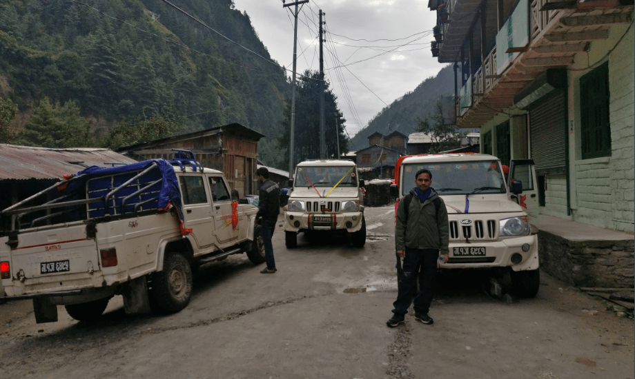
With no time to spend, we took the jeep. Jeep driver told us that road condition ahead was very bad and informed us about landslide ahead and also the bridge that joins Lamjung to Manang was swept away by a river. We had two choices either to stay at Besisahar or to travel up to where the driver could get us. We being adventurous souls chose the second option.

The road after Besisahar was very very difficult and indeed road was blocked by a landslide. The Lamjung district road department officials had sent heavy dozers to clear the way. The driver told us this is as far as he could drop us and told us that there were vehicles stuck at the other side of the landslide. We walked through the landslide and reached the other side and convinced one driver to drop us at the bridge that we were told was swept by the river. We were happy to learn that Manang district road department officials were constructing temporary bridge there because hundreds of vehicles were blocked in Manang from about 2 months due to heavy raining Monsoon season and scheduled to open the same day. With high hopes, we were amazed to see that the department indeed opened the bridge. It was around 8 pm when we reached there. We offered twice the usual fare to the driver to take us Chame, the district headquarter of Manang district about 3 hours away. He agreed.
We reached Chame (2,650m) under heavy rain at around 11 pm only to find that the whole town was sleeping. We knocked on one hotel door and then another. Also while searching for a hotel we found another single soul who happened to reach Chame at the same time as us and we offered him a company so that we all could spend the night at the same place. After knocking here and there finally, one guy opened us, showed us the room and also accepted our request to make us one bowl of noodles. Pure Nepali hospitality at it’s best.
We were happy to start the day with a clear sky. We went to the lobby to have breakfast. We had a conversation with our companion for the night – driver and a new guy. The new guy was a Micro-hydropower specialist and was there for hydropower maintenance tasks at Thorong Phedi. So, we had one guy who was going towards the same place but with a different purpose. We offered him to join us up to the point where we could be traveling the same destination and he agreed happily. Driver while listening our conversation offered help in getting us jeep from Chame to Manang. He phoned here and there and found that one of his friends was going to Manang. He even managed to make jeep-fare at a bargain price. We thanked him and bade farewell. While paying at Lobby, hotel-owner warned us no one would open their door in the middle of the night at Manang as they did so warned us not to travel beyond 6 or 7 or else we had to spend the night outdoor at the Himalayas freezing weather. We thanked her and the guy who opened their door late at night.
There was the jeep promised for us. Jeep was loading stuff for the Manang so during the waiting time, we traveled to local schools, hot-water bathing spots, Police and Army stations near Chame. After all, stuff was loaded we got into the jeep and started our journey towards the beautiful town of Manang.
From Chame to Manang, we traveled across apple orchard at Barthang, view of famous Swargadwari mountain, dangerous road carved in mountains, Humde airport, hilly villages of Pisang and upper Pisang, the monastery at Braga and beautiful valley of Manang. We bribed driver at points where we wanted to have photo shots by offering him cigarettes as the hydro-power guy was a heavy smoker.
We reached Manang (3,519m) at around 11 am. We ordered lunch there. The hotel staff informed us that it would take some time to prepare lunch. To utilize the time we went to the beautiful glacial Gangapurna Lake which is about 15 minutes walk from the town of Manang.
We returned to the hotel had lunch and took rest for some time. Our first destination was Tilicho lake before going to Thorong-la. For that, we had to trek extra 2 days and the route is separate to that of the Thorong-la. We separated from our hydropower guy as he was going to Thorong-Phedi and during departure, he told us that he would also cross Thorong-la if we made to the Thorong-Phedi after 3 days from separation.
We started our proper trekking from Manang. After 2 hours of trekking, we reached the village of Khangsar (3,756m). Khangsar village is small and many houses were being built there most probably to make a guest house and hotels. Khangsar is also the last place to get a motor road in Manang district. Those who wished to take their vehicles can park their vehicles there for certain fees. We had tea in Khangsar and we continued our trek to the next destination. We reached Shree Kharka (4,080m) in the evening. We booked a hotel room there and ordered dinner. The place was very cold and had a limited cellular network. The food was ok but the room was good and we also had an attached toilet.
We got up early around 5 am. The morning view of the mountain was very beautiful. There were mountains everywhere before us, at the side and behind our back.
We started our journey to Tilicho Base Camp and we knew the trail ahead is full of landslides (for about 2 hours the trail is all landslide area).

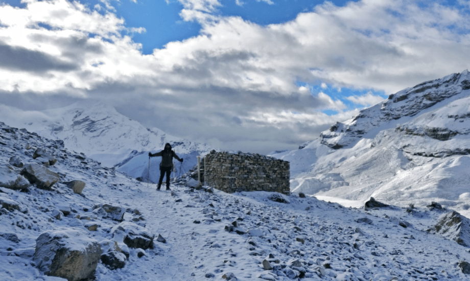
We reached Tilicho Base Camp (4,200m) at around 8:30 am. We ordered noodles soup and also informed the hotel owner that we might sleep there for the night after we came back from Lake Tilicho. After noodles soup, we started our trekking around 9:15 am. The hotel owner told us it would normally take 3 hours to reach Tilicho Lake. The trail from Tilicho Base Camp was very steep as we had to reach 4,919m from around 4,200m. The danger of Acute Mountain Sickness (AMS) or simply Altitude Sickness was also present. We had to stop at many points and even at a small distance especially at the point called Bais Ghumti. We reached Lake Tilicho (4,919m) around noon.

The highest lake in Nepal – Lake Tilicho – was very beautiful. I didn’t even imagine that I would found such a big lake at that height. Surrounded by mountains like Tilicho Peak, glimmering lake Tilicho made us fresh and we had forgotten the hardship we endured to be there. After taking rest for some time, we headed for a lake. We washed our face, fetched some water at our water bottle and relaxed at the lake for about 1 hour. Suddenly the weather at the mountain changed and we had to hurry up to be at the bottom of the trail Tilicho Base Camp. We encountered heavy snowfall and foggy weather and it made us hard to be in the trail. We hurriedly began descending. The trail was downhill so it made us easy to get back down. We reached the Tilicho Base Camp on time. We had time to reach Shree Kharka but we didn’t as hotel owner told us around 50 people left the area to reach Shree Kharka. As Shree Kharka had only 3-4 guest house, we wouldn’t get a room there. So, we spent the night there at Tilicho Base Camp as we had a room to spent the cold night.
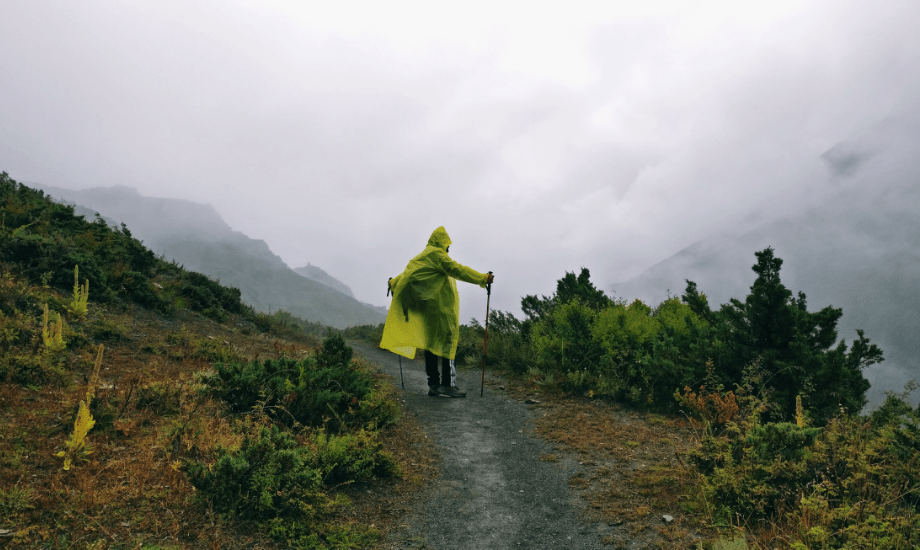
There was a heavy raining whole night. We started our day early but due to rain, we had to stop for a few hours. After a few hours, we decided to continue by wearing a raincoat and started our journey. We reached Shree Kharka and had breakfast there. After Shree Kharka, there is a separate route to go towards Thorong-la and we chose that route.
There was an abandoned village after Shree Kharka that looked very spooky. After a few hours of trekking, we reached Yak Kharka(4,018m). We had lunch there. It was around 2 pm. We had still a few hours and my friend recommended continuing the journey and we started from there. Locals told us it would take around 5 hours to reach Thorong-Phedi (base of Thorong-la). Luckily, it took us around 2 hours to get to Thorong-Phedi (4,600m). Booked a room there and ordered dinner. We began to search our hydropower guy and found that he had left to high camp at around 4 pm. We were a few hours late and hoped that we would meet him at some point.
We had trekked around 10 hours that day and for tomorrow we had to trek to one of the highest passes in the whole world – mighty Thorong-la. It rained heavily that night too.
I couldn’t get good sleep at night. It might be due to my first time sleeping at this height or might be fear of extremely high altitude trek the next morning. Locals told us it is best to leave early and it might be very windy at the top after sunrise and no matter what never sit down to take a rest because oxygen is very low and many have died while sitting.
We got up around 3:30 am and paid our bills and started our trek around 3:45 am. The trail was steep up to High Camp which is about 1-hour steep climb. I noticed there were water splashes when I set foot on the trail, it was pitch black and we were supported by our mobile phone light so I didn’t care more. After some walking, I asked my friend to show some light around and we found out yesterday’s heavy rainfall was heavy snowfall. It was my first time I have been into the mountain where there was nothing but snow.
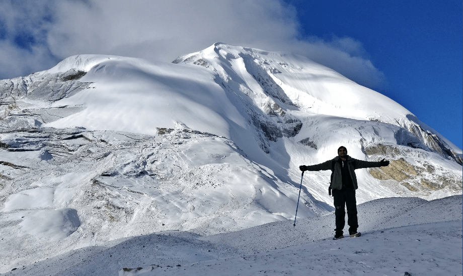
We were strong as we reached Thorong-La (5,416m) with around 3 hours trekking. Thorong-la (Thorong-pass) is a mountain pass that has Khatung yang mountain on one side and Yakawa yang mountain on other. This pass is used by locals from Manang and Mustang for trading. Thorong-La is the highest point in the Annapurna Circuit Trek. We had some photoshoot and had black tea on the top. I spent around 1 hour on top and we began descending.
The trail is very steep descending and after some point, my feet started to hurt very much. I told my friend to call our hydropower guy if the cellular network is good. While having rest there, we found our hydropower guy who happened to be descending. Locals were happy about his working at hydropower, they offered him horse riding service up to Thorong-la. My feet pain very much slowed my walking speed and it took us to reach about 4 hours for a path of 2 hours.
At the base of the Thorong-la, there is a very famous pilgrimage site of Muktinath at an altitude of 3,800m. Muktinath is a temple sacred to both Hindus and Buddhists and is one of the highest temples in the world. Being Hindu, we didn’t miss the chance to have a pilgrimage there. We bathed at the 108 sacred taps and visited a few temples there.

After some time at Muktinath, we headed to a town near Muktinath called Ranipauwa. We had snacks there and there was a bus stop. We arranged a bus to Jomsom, headquarter of the Mustang district.
We reached Jomsom (2,743m) around 4 pm. We bought bus tickets to Kathmandu for the next day and looked for a hotel to stay at night. We found one hotel, had a bath and left the hotel to enjoy our great trekking at a near pub. And everything is history.

We woke up in the morning had some tea. We bought some apples for the family back home. We waited for the bus scheduled to arrive at 11 am and started our 21 hours long bus ride to Kathmandu. The bus ride was very dangerous as we had to pass from Kaligandaki Gorge, the world’s deepest gorge, that separates two gigantic mountain of Annapurna and Dhaulagiri, world’s tenth and seventh highest mountain. There is one beautiful waterfall – Rupse Jharana. We were stopped at Pokhara to have dinner and with a non-stop bus ride of about 21 hours, we were in Kathmandu at 8:30 AM the following day.

Annapurna Circuit Trekking is one of the best trekking I have done. I still remember the rugged trek path, picturesque scenery, amazing landscapes and beautiful lake of Tilicho whenever I sat and try to memorize my time in the Himalayas. It is a beautiful trek and I recommend everyone to do it, especially now most of the trail has seen modernization. There is a road even higher than Manang and also on the opposite side, the road was near to Thorong-la. Enjoy it before full road track and full modernization hit these beautiful villages and towns on the other side of Himalayas.